#WorldTour: Isolated on Easter Island
Here we are, lost in the middle of the ocean, thousands of miles from Chile. Easter Island (from its original name: Rapa Nui) is one of the world's most remote inhabited lands, with its nearest neighbor Pitcairn Island (population 50) 2,078 km away. It's called Easter Island simply because it was discovered by a Dutchman on...Easter Day! Mysterious and exotic, the island fascinated us: the history of its people, the Moaïs and the cult of the bird-man make it a unique place in the world. We loved it and it was a real "coup de coeur".
We stayed for 3 and a half days, criss-crossing the island on foot (56 km) and in a vehicle with a guide (we had so many questions, we needed answers!). We were given a lot of information, and I'll try to summarize the island's fascinating history as best I can. It's worth noting that every explanation we were given always began with "according to archaeologists", "according to oral tradition", "it's possible that"... The lack of certainty contributes to the mystery that surrounds this island, although in the end, the greatest of all is the transportation of the Moai to their place of worship.
Day 1: Discover the unique town of Hanga Roa
On Easter Island, there's just one town - Hanga Roa - where all the hotels are located and where commercial and tourist activity is concentrated. It's small, very charming and right on the ocean. Our accommodation was right opposite a small beach with palm trees: a real change of scenery, and we were welcomed in true Polynesian style (the island is part of Polynesia) with necklaces of fresh flowers: a first for us.
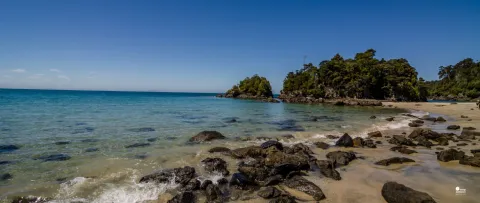
We strolled along the coast, which is magnificent, with volcanic rock, small cliffs and the blue of the ocean. The sunset wasn't bad either!
Day 2: Hiking in the east and center of Easter Island
Admire the Tahai site
We set off along the island's east coast, witnessing the first rays of sunshine at the Tahai site, where there's an Ahu (sacred platform) with 5 Moais lined up in a row, as well as two others to one side. The statues, representing tribal chiefs or deified ancestors, face away from the ocean, as their function was to protect the villages established near them, and so they looked out over them. Originally, all Moai had eyes, but today only one has been found (made of coral and black volcanic glass).
>> Leave well protected for your next trip: calculate your free premium <<
See the Ana Kakenga cave
Further on, we entered the Ana Kakenga cave ("ana" = "cave"), which looked directly out over the ocean with two windows in the cliff: there are many natural caves on the island, which are air tubes in the lava and were used by locals in times of war to take refuge and sleep in. Today, some locals camp in them at weekends. We visited another cave, Ana Te Paku, part of a large underground network, at the entrance to which banana and avocado trees grow, as the humidity makes the vegetation flourish.
Eating in front of Ahu Akivi
As we reached the center of the island, we had a picnic in front of Ahu Akivi, an impressive platform of 7 Moaïs, before climbing to the island's highest peak, the Maunga Terevaka volcano at 511m (not very high indeed!). From up there, we had a superb view of the whole island.
Day 3: Excursion to the west and north of Easter Island
Despite the island's small size (161 km2), there are some places that are still a long way from Hanga Roa, and we preferred to have at least one day with a guide to ask the ton of questions we had.
Visit the ancient village of Akahanga
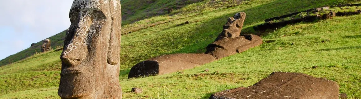
We started with the ruins of Akahanga, an ancient village with an Ahu, where you can see the base of the boat houses (small houses with roofs in the shape of an inverted canoe, used until 1864) and the ovens used by the inhabitants (heated stones and food put on leaves, then covered with these stones). The Moaïs are on the ground here, as they have not been raised and the ruins have not been restored.
>> Leave well protected for your next trip: calculate your free premium <<
Climbing the Rano Ranaku volcano
We then went to one of the places that impressed us most: the Rano Ranaku volcano, home to the Moaïs quarry, the only place where the stone used to make them can be found. There are numerous Moais in various stages of completion, from different periods and of different sizes. These never made it to their Ahu, probably due to clan wars and the fact that the quarry ceased to operate after 1,000 years of activity (690-1680). There are 887 Moaïs on the island, 397 of which are still in the quarry. The largest of them all measures 21 meters and is still in the rock. They were made in this order: profile, face, body and sides. Then they would carve until they had a small "peak" supporting the Moaï on the rock, and make holes to break this peak. They then moved the reclining Moai using tree trunks and ropes. It is estimated that it took 6 to 12 months to carve a Moaï (depending on its size). Most importantly, a Moai came to life only when it reached its Ahu and was fitted with its eyes.
The largest finished Moai measures 13 metres, and today only its head can be seen, as the rest is buried (they dug it up in 1956, then covered it over to leave it as it was). In the quarry, the Moaïs whose heads are all that can be seen are standing upright: after being detached from the rock, they were "slid" into a shallow hole to keep them upright and complete the finishing touches, notably the back. Some Moais have petroglyphs on their backs. We also went into the crater, where there's a superb (but drying) lagoon and more Moai on one of the inner flanks.
Stopping time in front of Tongariki
We then went to Tongariki, a fairly well-known place, as it's often the photo of the 15 Moai lined up that people see when they talk about the island. What's original here is that they've been straightened by a Japanese company following the exhibition of a Moai in Osaka to raise funds. I didn't mention that ALL the Moai, without exception, were toppled during wars between clans. The island was overpopulated, with up to 20,000 inhabitants, and wars broke out between the 17th and 18th centuries, until the French arrived and evangelized them all. Those seen standing on the Ahu today were later raised during restoration work. Nature hasn't helped the conservation of cultural heritage either, with a tsunami in 1960 displacing some of the Moais, but we've been able to replace them thanks to photos taken by explorers who had seen them before.
How did they raise the Moais on the Ahu? They used a ramp system, with a pile of stone higher and higher, and ropes. We lifted a Moaï in the ancestral way in 18 days. We almost always see images of Moai without a stone on their head, when in reality, each one had a Pukao on top. Most of them were lost when they were overturned, but you can still see them at their feet.
To the north, we saw Ahu Te Pito Kura, which had a magnetic stone at its center. Today, it has been set aside and, unfortunately, we can no longer approach it to test its magnetism!
To finish off this wonderful day of discovery, we went to the island's only sandy beach, Anakena, where 7 Moai are lined up in a row: it's a splendid place and yet another different landscape.
>> Leave well protected for your next trip: calculate your free premium <<
Day 4: Hiking in the south and west of the island
Admire the view from Rano Kau volcano
We're off to climb the Rano Kau volcano, culminating at a mere 324m: on arrival, a splendid panorama awaits us, with a perfectly circular crater and a lagoon covered in vegetation. The ocean in the background completes the picture. Further on, we discovered the ruins of the sacred village of Orongo: built as part of the birdman cult, it was used only once a year between the 16th and 19th centuries. Every Spring, chiefs or their representatives would take part in a competition, which consisted in swimming to the Motu opposite (islet) to fetch a Manutara egg and climbing the cliffs with it attached to their heads. The first to arrive became a sacred figure (of interest in terms of power for the tribe he represented) and lived in seclusion for a year. By this time, belief in the ancestors had gradually given way to this new cult. The houses are built in a totally different way to the boat-houses, as this is another, more recent era, and they have used volcanic stone here.
We then headed back down to Vinapu, a very special Ahu in that its construction is similar to that of the Incas (coincidence? We don't know!), with stones cut in a very meticulous and regular manner. It's the only one like it on the island.
A detour to the Pukao quarry
We ended our hike at the Puna Pau volcano, where the Pukao quarry was located: you can see some very large ones there, as they were cut more finely once they reached the Ahu. On the way back, we made a stop at Ahu Huri a Urenga, which seems a little forgotten, with its 4-handed Moai of which not many details are visible any more. Unfortunately, the deterioration of the Moais is a major problem, and for some years now they have been testing chemical treatments to preserve them.
Another activity on Easter Island is diving: the waters are among the clearest in the world, but unfortunately there aren't many fish because there is no coral reef. So there are rock formations to see, but also underwater Moais: we learned that they had been placed there on purpose for tourists, so there's nothing historical about them!
And the mystery of how the Moai were transported?
There is little archaeological evidence to suggest how they reached the Ahus, who could be dozens of kilometers from the quarry. Several theories have been tested by archaeologists on site, and our guide even took part in one of the tests in the 1980s. They placed a Moai on rolling trunks, bringing the trunks back to the front each time. Others used ropes with 40 people on each side of the Moaï and moved it like a piece of furniture, once to the left, once to the right. It worked, and might explain why legend has it that the Moai "walked" to their Ahu. Otherwise, there's always the theory that aliens came to move them...
Anne & Olivier
>> Leave well protected for your next trip: calculate your free premium <<